Greetings and welcome,
We are under a storm watch tonight. The southern half of Marinette County and Oconto County are under a winter weather advisory. Forest Co and most of northern WI are under a winter storm warning. The rain is expected to change to snow here about 9am Wednesday.
At the moment I am expecting 1-2″ with 2-4 possible. The bigger snow isn’t far away and a 50 mile shift in the precipitation band could make a huge difference.
Here is a screen cap from the Green Bay TV 2. Most models and forecasts that I have seen are in pretty good agreement.
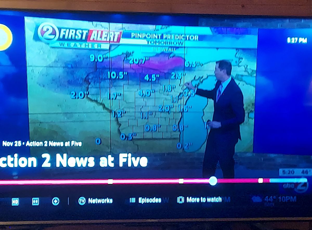
Note the 1.8″ for Lakewood quickly goes to 4.5 for Rhinelander.
Above the projected snow the storm will feature 40-50mph wind gusts. That is going to make for some rough travel with blowing snow. I saw where the Ohio Turnpike is banning high profile vehicles once the storm heads that way, so the wind is being taken seriously.
This storm is the entrance to winter. I’m picturing Jack Nicolson in The Shining, “Here’s Johnny!”. Our average high temperature is in the upper 30s. We will not see 32 after tomorrow morning for at least a week. There is a storm possible for the weekend that has potential, followed by a high temperature of 19 or 20 Monday and Tuesday.
The weekend storm looks nice from here. It is one of my observations that the forecast models often change after a big storm like tomorrow’s. At the moment the weekend storm looks like a 4-6″ storm for us. I will have a lot more confidence in it Thursday or Friday.
This storm is going to hit the UP of Michigan hard. There are blizzard warnings out and forecasts have some places getting 2+feet of snow. Add in sustained winds of 35mph gusting to 50 and travel will be nearly impossible. It will certainly help a lot of places get ready for their December 1 trail opening. I saw one forecast that said Hurley could get 24-30″ depending on which way the wind blows.
We will see how the storms work out tomorrow. It does look like we are off to the races. I will update as needed.
RJB